ENVIS Centre, Ministry of Environment & Forest, Govt. of India
Printed Date: Friday, January 9, 2026
Land & Water
- Journal of Hydrology : Reconstruction of January–April discharge of Zemu Chuu – A first stage of Teesta River North Sikkim Eastern Himalaya based on tree-ring data of fir » Click here
Author - Mayank Shekhar, Amalava Bhattacharyya
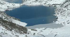
Wetlands of Sikkim
The total geographical area of the state is 7,096 sq. km. High altitude lakes accounting for 40.79 per cent of the total wetland area. Total 534 lakes are identified with 3325 ha area. Total lakes mapped as polygons are 259 with 3050 ha area. In addition 275 small lakes (<2.25 ha) are mapped as point features. Maximum number of lakes are of very small size (<10 ha). Large size lakes (>500 ha) are not observed in Sikkim. Most of it are fed by glaciers and considered sacred. The lakes are popularly called as Chhokha or Tso or Chhona (in Bhutia), Chho (in Lepcha) and Pokhari or Jheel or Tal (in Nepali)..... Read More
| Distribution of high altitude lakes in relation to elevation gradient in Sikkim |
| Sr No |
Category |
<Altitude range (m) |
No. of Lakes |
Area (ha) |
| 1 |
High Altitude |
3000-4000 |
6 |
19 |
| 2 |
Higher Altitude |
4000-5000 |
323 |
1209 |
| 3 |
Very High Altitude |
>5000 |
205 |
2097 |
| Total |
534 |
3325 |
Source : Space Application Centre, Indian Space Research Organisation (ISRO) Ahmedabad - January 2011
» Click here for the complete report
|
About Wetland Conservation in Sikkim
|
More on Wetlands of Sikkim
- High Altitude Himalayan Lakes
Source: National Wetland Inventory and Assessment Project (Sponsored by MoEF, GoI) Space Application Centre, Indian Space Research Organisation (ISRO) Ahmedabad - January 2011
- Sikkim -Wetlands of India
Source: Nation-wide Wetland Mapping Project, (Sponsored by MoEF, GoI) Space Application Centre, Indian Space Research Organisation(ISRO) Ahmedabad - June 1998
- Wetland Sites of Sikkim
|
Wastelands of Sikkim
Treatment of Landslides & Soil Erosion Control
|